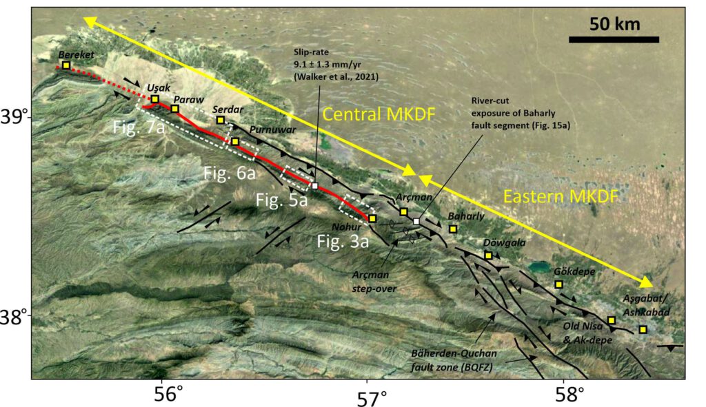
The Main Kopetdag fault (MKDF) of Turkmenistan is a key tectonic feature within the active tectonics of the Arabia-Eurasia continental collision and the geodynamics of the South Caspian basin. The fault runs along the edge of the Kopetdag (or Kopeh Dagh) mountains, which form the northern margin of the Arabia-Eurasia collision zone. The tectonics are complicated by proximity to the South Caspian Basin, which is an enigmatic ‘block’, filled with up to 20 km of Cenozoic sediment, and possibly floored by oceanic crust of Mesozoic age. The South Caspian is moving relative to its surroundings, with a roughly northwest motion relative to Eurasia that introduces oblique right-lateral and shortening components across the western Kopetdag. The lateral component decreases eastwards as the influence of the Caspian diminishes, and the Kopetdag instead accommodates Arabia-Eurasia shortening.
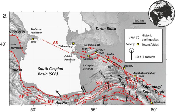
The MKDF is a right-lateral strike-slip fault with a very clear expression in the landscape and yet very little is known of its long-term slip rate or its potential for generating earthquakes. Destructive earthquakes are known within Turkmenistan, including large events in 1895, 1946 and 2000 in the Caspian lowlands, and in 1948 in an earthquake that destroyed Ashgabat, the capital city of Turkmenistan. However there is no record of large events along the intervening fault length of ~300 km.
A collaborative study between researchers at the Institute of Seismology and Physics of the Atmosphere in Ashgabat, along with colleagues in Iran, Germany, and the UK has aimed to characterise the slip-rate and seismic potential of the MKDF, and to use these results to gain a better understanding of the geodynamics of the South Caspian. In a series of three papers published this year we present geological slip rates and imaged decadal accumulation of strain across the fault. We have also found palaeoseismic evidence for large magnitude earthquakes along this major, and yet seismically quiet, fault. Our results suggest relatively rapid slip and a young initiation of the present day tectonics.
Two of the papers (both open access) established the slip-rate of the MKDF over late Quaternary and decadal timescales, and we were relieved to find that the two sets of measurements were in close agreement, with almost a centimetre of right-lateral slip. Previous attempts to use satellite radar to measure interseismic strain accumulation across the MKDF have suffered from large atmospheric noise, and the only available GNSS measurements have to be extrapolated from across the border in Iran. In a paper published in Geophysical Journal international, Interseismic deformation and strain-partitioning along the Main Köpetdag Fault, Turkmenistan, with Sentinel-1 InSAR time-series | Geophysical Journal International | Oxford Academic (oup.com) Dodd’s et al. measured 9 +/- 2 mm/yr of right-lateral slip and 4 +/- 2 mm/yr of shortening.
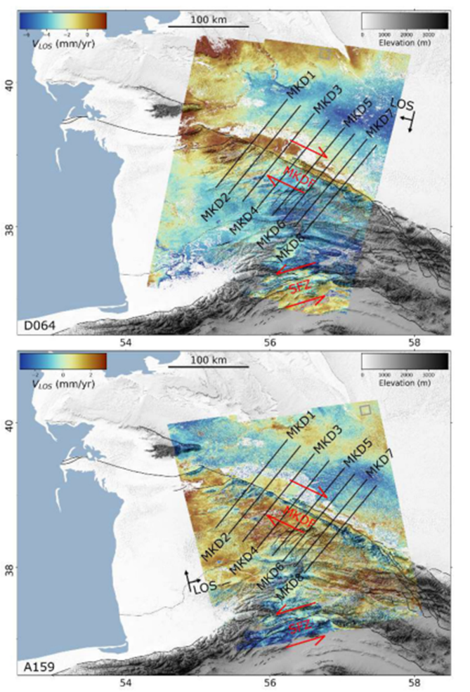
Walker et al. Slip‐Rate on the Main Köpetdag (Kopeh Dagh) Strike‐Slip Fault, Turkmenistan, and the Active Tectonics of the South Caspian – Walker – 2021 – Tectonics – Wiley Online Library determined a geological slip-rate of 9.1 +/- 1.3 mm/yr, but found a much smaller amount of shortening, suggesting that much of the shortening imaged by InSAR is not accommodated across a single frontal thrust.
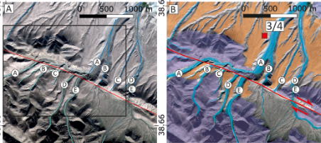
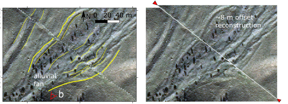
The rapid slip rates are important in suggesting that the region has undergone a relatively recent tectonic reorganisation, as the cumulative displacements on the MKDF can be accommodated in only 3-5 Ma. It is also surprising that no large earthquakes are recorded, given the rapid slip-rate and the long historical record across large parts of the Arabia-Eurasia collision zone. In the third paper Dodd’s et al. A Major Medieval Earthquake on the Main Köpetdag (Kopeh Dagh) Fault, Turkmenistan | Bulletin of the Seismological Society of America | GeoScienceWorld mapped ruptures from a previously unknown earthquake that are still preserved along much of the length of the fault. The length of the rupture zone, and the distribution of slip, suggest a magnitude of Mw 7.4-7.8. The ruptures are of probably medieval age. They displace surface archaeological remains and are dated through trenching at 600-800 yrs. BP.
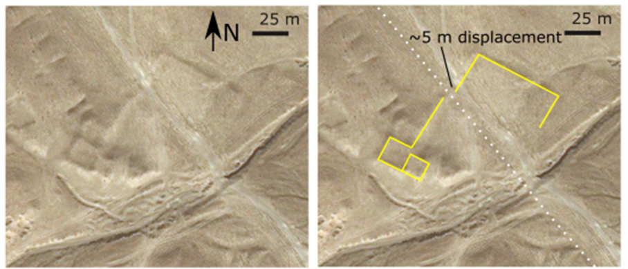
~5 m displacement in the walls of a small undated archaeological site.
The palaeoseismic study has implications for the hazard posed by the MKDF and also provides insight into the completeness of historical earthquake records in the surrounding region. This event also presents implications to comparable regions around the world (e.g., Iran, China) that use extended historical earthquake catalogs with assumed levels of completeness to inform seismic hazard assessment. It is likely that additional major earthquakes remain to be discovered through continued remote sensing, paleoseismology, and through the interpretation of archaeological and historical sources.
The collaborative research began within the UKRI Earthquakes without Frontiers program (2011-2017) and it currently supported through the Leverhulme Trust ‘EROICA’ program. We also acknowledge support through the Global Challenge Research Fund, through COMET, the UKRI LICS program, the DigitalGlobe foundation, and through the Committee for Earth Observing Satellites Seismic Hazard Demonstrator project.