Our team has published a new paper on the seismic hazard in the Almaty region, Kazakhstan. We use high resolution satellite imagery to map faults around Almaty, Kazakhstan, and then use GEM’s OpenQuake to calculate shaking, damage and losses to the city from earthquake scenarios. Here’s what we found.
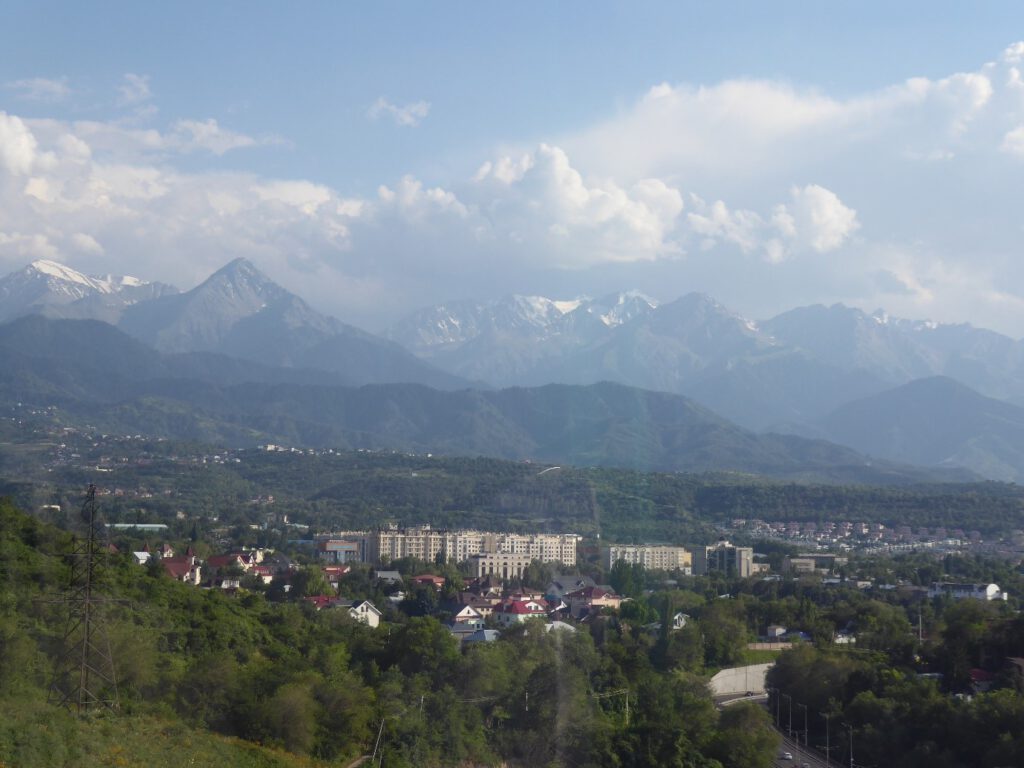
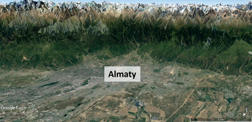
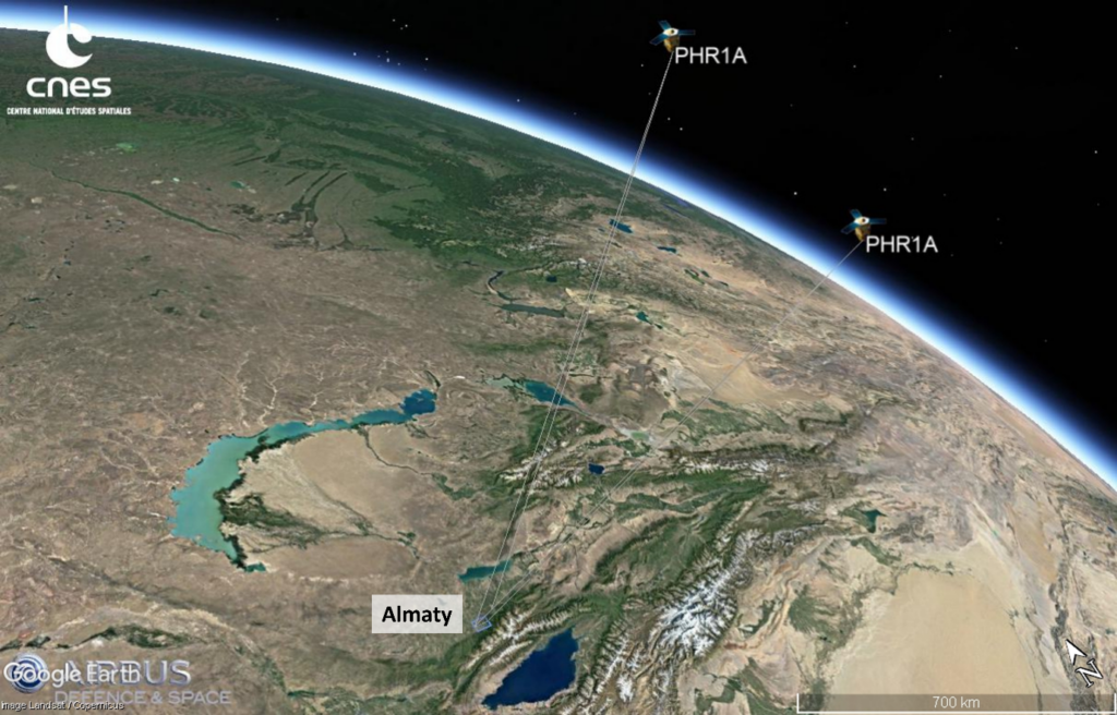
This is a Google Earth image of Almaty city, looking ~south. This has 3x vertical exaggeration – Almaty city is ~700 m elevation, and those snow-topped peaks are 4000 m. Many cities grow near mountains because of the protection, but these mountains are formed by earthquakes.
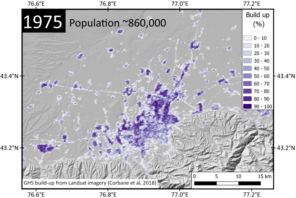
Almaty has been damaged by large earthquakes in the past, including 1887 (Verny, magnitude ~7.3), 1889 (Chilik, Mw ~8.0) and 1911 (Chon-Kemin, Mw ~8.0). So big earthquakes happen here. But Almaty has grown in size significantly since these last events, and has now ~ 2 million residents.
And earthquakes don’t just occur in the mountains. Earthquakes happen on faults, and sometimes these faults at the base of mountains can ‘step’ from the edge of the mountains into the basins. So potentially Almaty could be built on faults which are now hidden by the city.
This is where high-resolution satellite imagery comes in. Satellite ‘digital elevation models’ give the ground height. ~30 m resolution images can map big faults at the edge of mountains, but to map small, subtle faults hidden by a city we need higher resolution, ~2 metres.
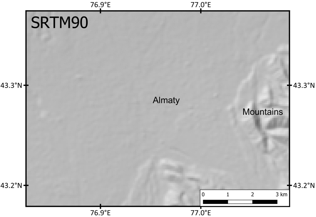
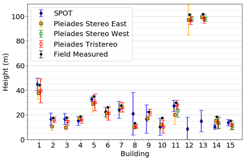
In this paper we use pairs of optical satellite images (Pléiades + SPOT), taken of the same location but at different angles. Using these angles we can calculate elevation across the whole image. At 2 m resolution we see buildings + trees.
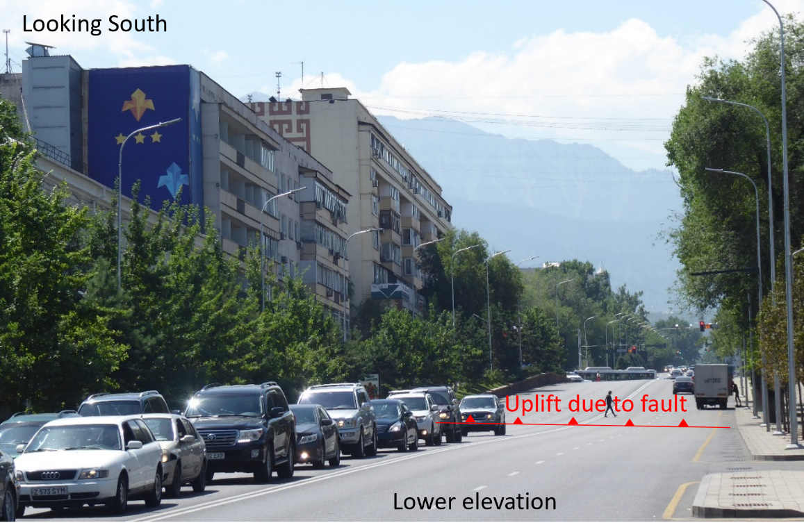
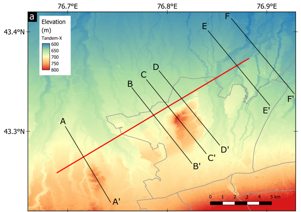
Using high-resolution maps of height, we look if there are places where faults have lifted the ground, under the city. A fault in Almaty has been identified before (Paper by Grützner et al., 2017). It has lifted the street up, and the same thing can be seen on parallel streets.

We also use TanDEM-X data (12 m) to map folding north of Almaty. From the shape of the fault, if there were a fault causing this folding it would dip south. Meaning that lots of the city would be directly above the fault.
Earthquake scenarios
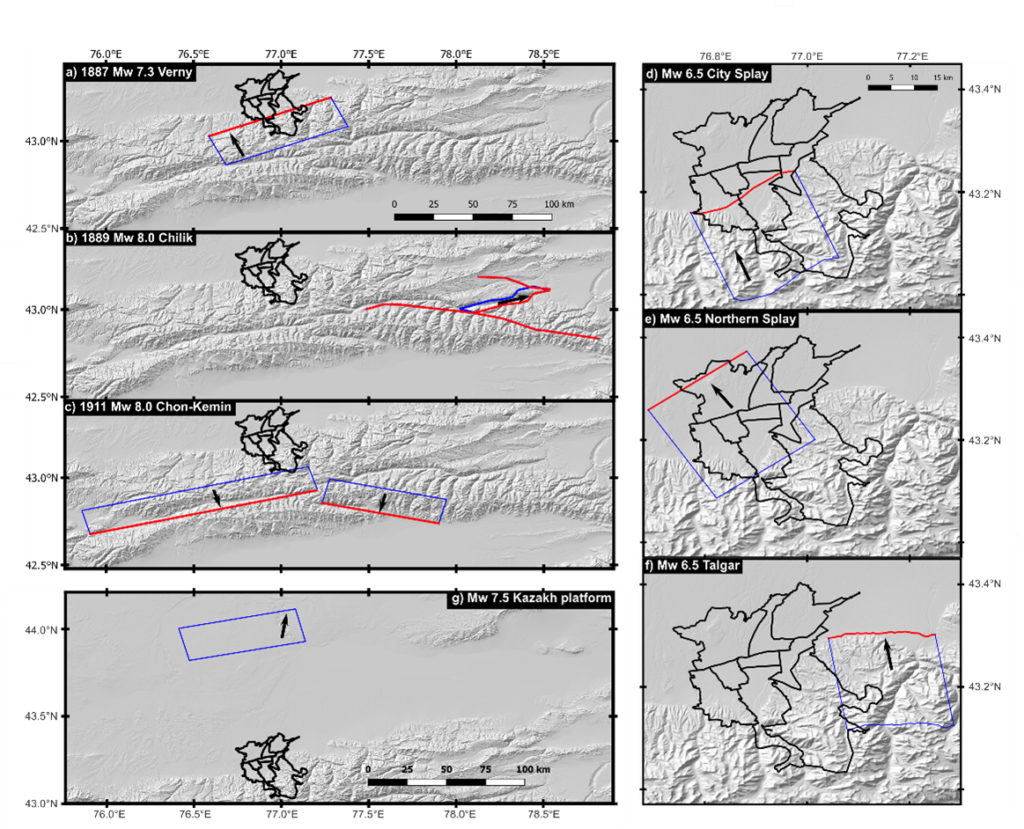
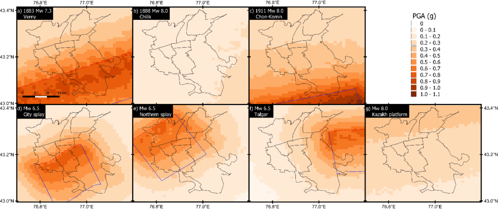
We identify a number of plausible earthquakes that might cause damage to Almaty. This map shows what we think they might be – with the surface in red and the fault at depth in blue (faults aren’t really rectangular like this, but we use simple models):
The OpenQuake Engineuses fault geometry, size of the earthquake, ground info, as well as building information (the number, material, height, occupants, cost). Then it calculates ground motion, damage, and losses that might occur uses ground motion prediction equations.
Earthquake consequences
Using our input earthquakes, here is the shaking that Almaty would experience:
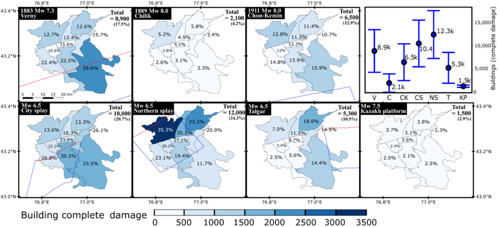
Here are the number of completely damaged buildings:
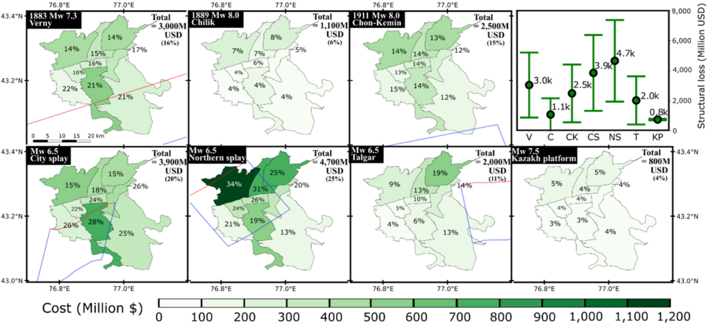
Here is the economic cost of replacing buildings:
And this would be the fatalities (which really shows how serious earthquakes would be for Almaty):
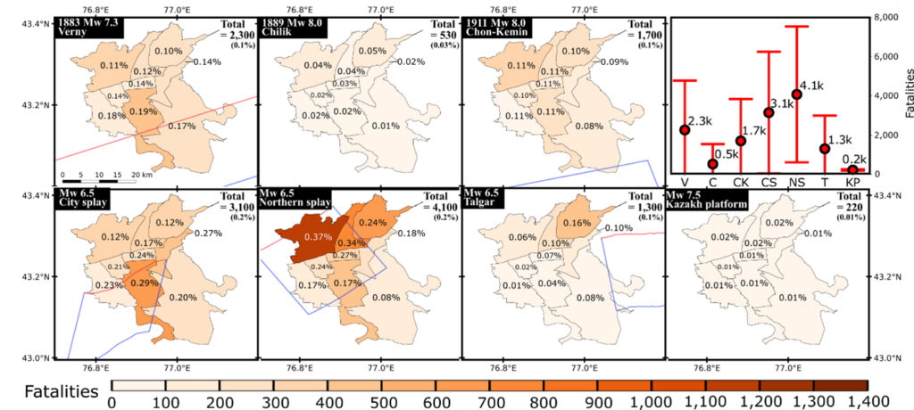
This shows earthquakes close to the city, even if they are much smaller magnitude than those far away, can cause a lot more damage and loss to Almaty. The worst scenario we model is the northern fault, which could cause ~12,300 completely damaged buildings and ~4,100 fatalities.
Also, we can use satellite estimates of elevation to calculate building heights, which can potentially help us do earthquake loss calculations. Long story short – we can get building height estimates, there are sometimes some problems and it’s better with higher resolution DEMs.
Key points
- Digital elevation models derived from high-resolution satellite imagery can map active faulting near cities and determine building heights.
- Our earthquake scenario risk calculations show a moderate earthquake on a fault in north Almaty would cause considerable damages (building collapses) and loss (economic and fatalities) due to how close it is to the city.
- It’s really important to properly characterise fault location and geometry close to cities in order to work out the relative level of seismic hazard and risk.
We have lots to do to make cities more resilient to earthquakes! So please read our paper:
Amey, R. M., Elliott, J. R., Hussain, E., Walker, R., Pagani, M., Silva, V., … & Watson, C. S. (2021). Significant Seismic Risk Potential from Buried Faults Beneath Almaty City, Kazakhstan, revealed from high‐resolution satellite DEMs. Earth and Space Science, e2021EA001664.
We’re happy to discuss further, either in the comments below or via email, Twitter, or – even better – in person.
References and further reading
- Abdrakhmatov, K. E., Walker, R. T., Campbell, G. E., Carr, A. S., Elliott, A., Hillemann, C., … & Sloan, R. A. (2016). Multisegment rupture in the 11 July 1889 Chilik earthquake (Mw 8.0–8.3), Kazakh Tien Shan, interpreted from remote sensing, field survey, and paleoseismic trenching. Journal of Geophysical Research: Solid Earth, 121(6), 4615-4640.
- Amey, R. M., Elliott, J. R., Hussain, E., Walker, R., Pagani, M., Silva, V., … & Watson, C. S. (2021). Significant Seismic Risk Potential from Buried Faults Beneath Almaty City, Kazakhstan, revealed from high‐resolution satellite DEMs. Earth and Space Science, e2021EA001664.
- Grützner, C., Walker, R. T., Abdrakhmatov, K. E., Mukambaev, A., Elliott, A. J., & Elliott, J. R. (2017). Active tectonics around Almaty and along the Zailisky Alatau rangefront. Tectonics, 36(10), 2192-2226.
- Krüger, F., Kulikova, G., & Landgraf, A. (2017). Instrumental magnitude constraints for the 11 July 1889, Chilik earthquake. Geological Society, London, Special Publications, 432(1), 41-72.
- Krüger, F., Kulikova, G., & Landgraf, A. (2018). Magnitudes for the historical 1885 (Belovodskoe), the 1887 (Verny) and the 1889 (Chilik) earthquakes in Central Asia determined from magnetogram recordings. Geophysical Journal International, 215(3), 1824-1840.
- Kulikova, G., & Krüger, F. (2015). Source process of the 1911 M 8.0 Chon-Kemin earthquake: Investigation results by analogue seismic records. Geophysical Journal International, 201(3), 1891-1911.
- Pagani, M., Monelli, D., Weatherill, G., Danciu, L., Crowley, H., Silva, V., et al. (2014). OpenQuake engine: An open hazard (and risk) software for the Global Earthquake Model. Seismological Research Letters, 85(3), 692–702.
- Silva, V., Crowley, H., Pagani, M., Monelli, D., & Pinho, R. (2014). Development of the OpenQuake engine, the Global Earthquake Model’s open-source software for seismic risk assessment. Natural Hazards, 72(3), 1409–1427.
- Tatevossian, R. E. (2007). The Verny, 1887, earthquake in Central Asia: Application of the INQUA scale, based on coseismic environmental effects. Quaternary International, 173, 23-29.