The COMET Central Asia Fault Database integrates decades of fault mapping and field-studies by researchers from the UK NERC Centre for Observation and Modelling of Earthquakes, Volcanoes and Tectonics (COMET), and global collaborators.
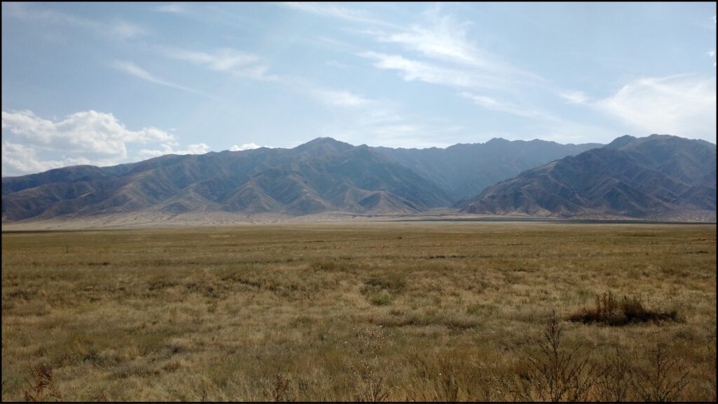
Central Asia is home to one of the world’s great mountain ranges–the Tien Shan–which is formed by vigorous crustal convergence across a multitude of tectonic faults. Here we describe the motivation to assemble the database and the choices that we have made in its structure, which are based on utility, necessity, and limitations in available information. We are working towards a full public release of the dataset, so keep an eye out!
Key points:
- COMET researchers have assembled a comprehensive database of active faults and associated attributes within Central Asia.
- The database is comprised of structures identified by COMET researchers from both remote and field mapping (rather than a digitization of all published maps).
- Faults are represented at three scales to suit various applications, e.g., geotechnical site exposure, geomorphic and neotectonic science, structural continuity for regional deformation models, and an inventory of seismogenic sources.
Background Motivation
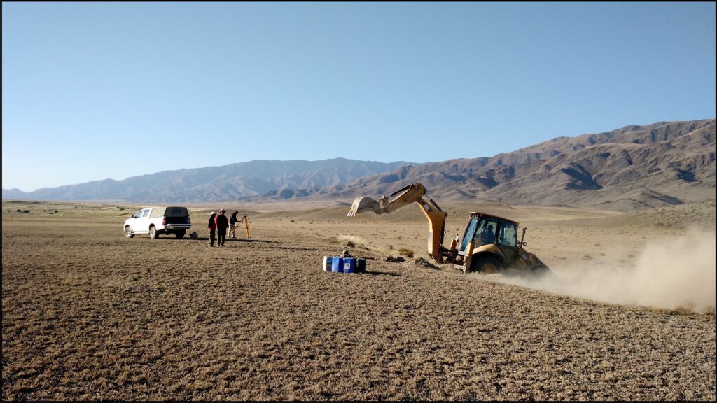
COMET researchers have been investigating active tectonic structures across the Central Asia region since the early 2000s through programs such as Earthquakes without Frontiers and Looking Inside the Continents from Space, along with local partner institutions in the region such as the Kyrgyz Institute of Seismology. Alongside remote mapping, field campaigns with collaborators have produced a large amount of tectonic and earthquake related information. The COMET Central Asia Fault Database assembles these data to produce a cohesive fault database of use to a wide range of geoscientists, as has been done recently across other regions of the planet.
Individual contributors had mapped faults at variable times (~2000 to present), variable resolutions (field-mapping to coarse satellite imagery), and for variable purposes (field site to continental-tectonic scale studies). Rather than reduce this variability to a single representation of the fault network, we produce a database that contains three resolution levels, to increase suitability for various applications.
Database Structure
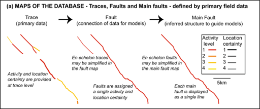
The three chosen resolution levels in the COMET Central Asia Fault Database are modified from the strategy of the recent Fault2SHA Central Apennines database [1]. The Central Apennines database has three major fault ‘levels’. These build from surface rupture or geomorphic traces (‘Trace’) into interpolated and connected structures (‘Fault’), and finally to simplified seismogenic sources (‘Main Fault’) (Figure 1), with that last level set up to be directly input to a PSHA (probabilistic seismic hazard assessment) model. The database has full metadata attached to each mapped fault (see Fig. 2 of [1]), again setup for PSHA modelling.
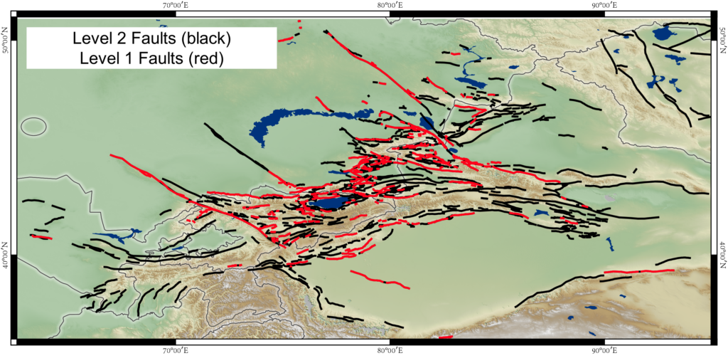
Due to some fundamental differences in the fault network, the nature of the mapping, and the availability of data, the COMET Central Asia Fault Database does not directly replicate the Fault2SHA Central Apennines database. For example, the Central Asia database has an order of magnitude more faults to consider. At the ‘Fault’ level of the Central Apennines database there are 88 faults, while in ‘Level 2’ of the Central Asia database, there are ~208 faults. The majority of these Central Asian faults have not been comprehensively studied, and do not have estimates of kinematics or activity rates.
For these reasons, the COMET Central Asia Fault Database follows a “geodesy-centric” focus rather than a “PSHA-centric” focus. We avoid making inferences about the seismic hazard potential of the faults, instead focusing on including all faults which may be accommodating strain and tectonic motion in the region.
Constructing the Database
All individual mapping contributions were combined and assigned to one of three options: Level 1 fault; Level 2 fault; or non-preference. Level 1 and Level 2 (Figure 4) form the backbone of the COMET Central Asia Fault Database, with Level 3 being a derivative product of the Level 2 database incorporating additional considerations of simplification, activity rates, and connectivity.
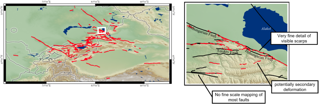
Level 1 – Geomorphic/Rupture mapping – Figure 5
- Contains the finest scale (highest resolution) mapping available.
- Linework may include primary fault rupture and secondary discrete surface breaks.
- Many faults included in the database have no fine-scale (1:<24,000) mapping, and thus have no representation in the Level 1 database.
- Differences between faults included in Level 1 and Level 2 highlight areas where more detailed neotectonic studies are needed.
- Original mapping is included without editing.
- Potential uses include paleoseismology, earthquake geology, geotechnical site studies, PFDHA (Probabilistic Fault Displacement Hazard Analysis)
Level 2 – Structural/Geodetic mapping – Figure 6
- Contains representations of through-going faults at the kilometre scale (1:>24k).
- Identified based on tectonic geomorphology, geodesy, or instrumental/historic surface rupture, and interpolated based on structural continuity.
- Excludes short (approx. < 5 km), discontinuous features and minor branching strands which are likely to be secondary or structurally subsidiary features.
- Original mapping is edited to produce coherent structures using a minimum of interpretation. For instance:
- Small gaps and steps in visible rupture unlikely to be tectonic in origin (e.g., gaps from sedimentation/erosion) are joined.
- Large gaps and steps (~3-5 km) which may or may not be tectonic steps or segmentation are retained, even if geomorphology/topography continues (e.g., ridge front).
- Coherent lines mapped through changes in strike are retained, even if these may or may not represent tectonic steps or segmentation
- Potential uses: geodesy, tectonic modelling, seismic hazard assessment, fault network analysis.
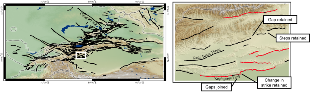
Level 2 is largely treated as ‘complete’, though further additions and edits may be required as work progresses. Current work focuses on populating metadata and collaboratively producing a Level 3 database representing ‘seismic sources’. We expect to continually update Level 1 as finer scale mapping is completed/contributed for any of the Level 2 faults.
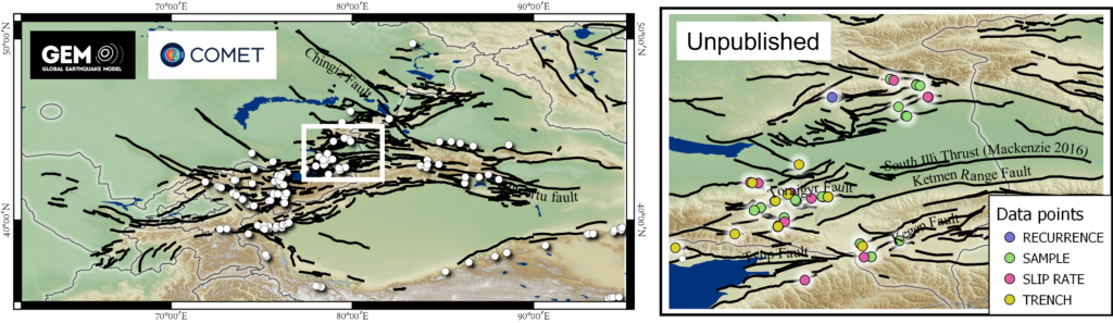
Ongoing work: Fault attributes and metadata – Figure 7
A vital and valuable part of the fault database is the suite of attributes attached to each fault. Currently we’re collating all raw data from both published and unpublished material. Once this is completed, we will hold a workshop with experts on Central Asian active tectonics to decide what slip-rate, geometry, etc. should be assigned to each fault.
In the process of documenting data in published papers, we’re double-checking all named faults in published figures are included (with their names) in the database. This does not include re-mapping all lines in all published figures, but does involve ensuring major known faults and their metadata are accurately captured in Level 2 of the database.
The attributes being collated include:
- Geometry: dip estimates, strike, trench dip, slip vector.
- Rates: slip-rate, shortening rate, uplift rate, throw rate.
- Recurrence intervals, dated events, magnitude estimates.
- Basic details of where high-resolution remote sensing exists.
- Samples: locations, methods, results, reasons.
- Earthquakes: instrumental or historically documented earthquakes on a particular fault.
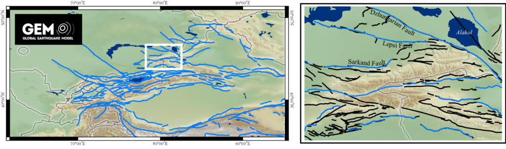
Ongoing work: Interpreting Level 3 Seismogenic Sources
We are currently collaborating with the Global Earthquake Model (GEM, https://www.globalquakemodel.org/gem) to produce a third database level which represents the main sources of seismic hazard in the region. This Level 3 will be a derivative product based on Level 2 linework.
GEM have produced a preliminary database of remotely mapped faults, which will be supplemented by the COMET Level 2 database (Figure 8). GEM are also actively compiling PSHA related metadata including fault dips and slip-rates, which complements the COMET metadata work.
Collaborative efforts are currently focused on deciding which faults represent credible contemporary seismic hazards based on published slip-rates and geodesy, or from their apparent activity as observed remotely in the geomorphology.
Future work: Expert consultation workshop
Once the metadata database and Level 3 are complete, we aim to hold a workshop with experts in the field of Central Asian active tectonics. The aims of this workshop will be to:
- Resolve appropriate geometry (e.g. dip) and activity levels (e.g. slip-rates) onto all Level 3 faults, based on either published data or community consensus.
- Identify whether any Level 1 lines have been erroneously excluded from Level 2 as ‘secondary deformation’.
- Identify Level 1 scale mapping that is not yet included in the database.
- Identify Level 2 lines where gaps/steps should be joined, or where lines should not be joined due to probable segmentation.
Future work: Full public release
Once linework and metadata have been reviewed through expert consultation, we aim to release the full database to the public via the COMET website and in an accompanying publication. We will develop an interactive platform in which all levels and metadata are viewable and downloadable. We will also provide an avenue for the wider research community to contribute or suggest edits to the database. So, keep an eye out for this release!
In the meantime, if you’d like to be involved or would like more information, please get in touch with Tamarah King via tamarah.king@earth.ox.ac.uk
[1] J. Faure Walker, B. Paolo, P. Bruno, R. Gerald, B. Lucilla, O. Scotti, F. Visini, L. Peruzza, Fault2SHA Central Apennines database and structuring active fault data for seismic hazard assessment, Nat. Sci. Data. 8 (2021) 1–20. https://doi.org/10.1038/s41597-021-00868-0.